The uses of LiDAR
What applications are there for LiDAR systems?
Airborne LiDAR Mapping
Forestry Management and Planning
LiDAR is unique in its ability to measure the vertical structure of forest canopies. As well as mapping the ground beneath the forest, LiDAR is able to predict canopy bulk density and canopy base height. Both of these factors can be used for, amongst other things, canopy fuel capacity for use in fire behaviour models. LiDAR surveys allow large scale surveys to be taken with a level of cost-effectiveness not previously available. Another use of LiDAR is the measurement of peak height to estimate the root expanse. This is a valuable tool for insurers when considering house in particular areas.
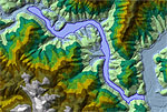
Flood plain modelling.
Flood Modelling
Features like buildings, constructed river banks or roads have a great effect on flow dynamics and flood propagation. Only high-resolution input data can solve the purpose that relates to the systems topography as well as to the identified features. Frequent urban flooding is observed in many parts of the world over the past decades and an urgent need is identified to improve and increase our modelling efforts to address the effect model input data has on the simulation results. Even differences of a few meters can means a lot in loss calculations in urban areas. LiDAR has brought this level of detail to the industry allowing for much more accurate flood prediction models to be created.
LiDAR data can also be incorporated into relief, rescue and flood simulation software to provide advanced topographical information.
Pollution Modelling
LiDAR has a unique ability to detect particles in both water and air. As LiDAR uses short wavelengths of light in the visible spectrum , typically ultraviolet, visible or near infrared, is it possible to image an object or feature only about the same size as the wavelength or larger. This makes it particularly sensitive to aerosols, cloud particles and air molecules. Pollutants such as carbon dioxide, sulphur dioxide and methane are all detectable with LiDAR. Combined with a building or terrain model this allows researchers to monitor and effectively reduce pollutant build up is certain areas.
In addition to airborne pollutants is LiDARs ability to assist in the detection of noise and light pollution. By using information gathered from known factors, such as the direction of light and the source of noise it is also to determine affected areas.
Mapping and Cartography
LiDAR's high resolution and accuracy has enabled it to be used in the creation of maps. Used in conjunction with aerial photography, LiDAR can assist in road, building and vegetation mapping. The 3D aspect of LiDAR makes it especially suitable for mapping terrain models, including complex mountain topography. Other topographical data can be derived from LiDAR such as high-resolution contour maps.
Urban Planning
Urban, city, or town planning is the discipline of land use planning which explores several aspects of the built and social environments of municipalities and communities. LiDAR data is a relatively new technology for obtaining Digital Surface Models (DSMs) of the earth's surface. This data, when combined with digital orthophotos, can be used to create highly detailed DSMs and eventually Digital City Models. Using special software it is also possible to create estimated surface models of buildings from the original LiDAR data. This technology allows large area models to be created in a very short space of time.
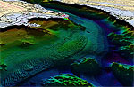
Coastline management.
Coastline Management
Combining topographical and bathymetric LiDAR enables surveys to be taken of the coastline, giving the maximum overlap between the land/sea interface whilst minimising the potential for data gaps as a result of breaking waves from the surf zones. Surveying the shallow areas around the coast would normally be quite difficult and time consuming using a multibeam survey. Large areas can be flown in a short space of time. This gives a snapshot of the coast at specific time intervals. Combining multiple datasets over many years can give a valuable insight into occurance of coastal erosion.
Where the coast has no definable features it can often be impossible for the use of photogrammetry due to the lack of Ground Control Points (GCPs). It may also be impossible to access coastal features such as cliff faces for mapping purposes. In these cases an airborne LiDAR survey is crucial.
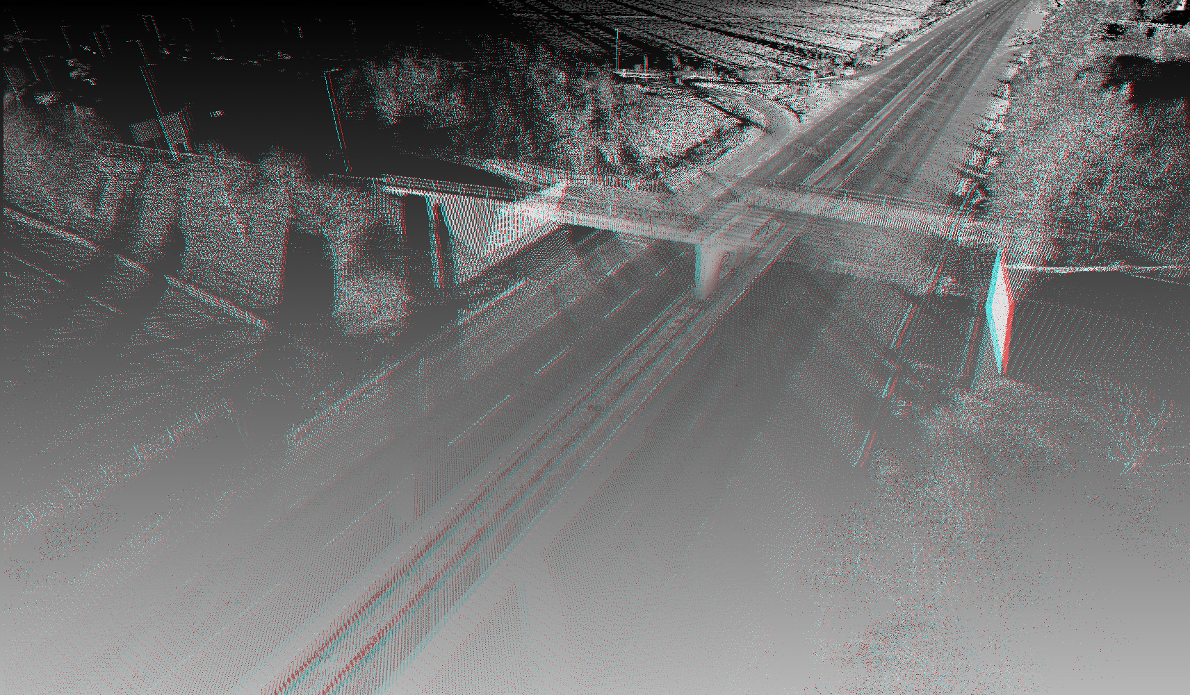
3D road mapping.
Transport Planning
Transportation corridor mapping to support engineering planning and change detection of road networks requires high spatial resolution and high scale engineering mapping accuracy. With the latest developments of LiDAR sensors the accuracy potential of LiDAR data has improved significantly.
Airborne LiDAR data can be used to capture large amounts of data over large areas and ground based LiDAR can be used to add a greater amount of details in specific areas. This method allows the most cost effective process for site-specific LiDAR capture.
Using LiDAR to uncover fault lines.
Oil and Gas Exploration
Differential Absorption LiDAR (DIAL) can be used to detect trace amounts of gases in the atmosphere above hydrocarbon deposits. The detection of gases can be analysed for a measurable concentration of anomalies. This is a relatively new method of exploration that is being developed at the moment.
Once a suitable site has been found LiDAR mapping comes into use, providing accurate models of the terrain in which the project is to be undertaken. The use of LiDAR in this way can help minimise the environmental impact as well as the overall cost by ensuring only the necessary area is developed.
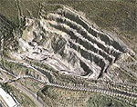
Laser-scanned quarry volumetrics.
Quarries and Minerals (Volumetrics and Exploration)
As with the Oil and Gas Exploration, LiDAR has uses for the quarrying industry. It can be used to determine air pollutants as well as surveying land around the area to see it's suitability, as well as give an accurate indication of environmental impact.
LiDAR can also be useful for existing quarry sites. Its high accuracy means that a quick survey can be undertaken that will give precise volumetric measurements within a few centimetres.
The constant changing of a quarry or mine environment requires laser scanning to be performed on a regular basis. A quick turn-around is imperative to the smooth running of the quarry.
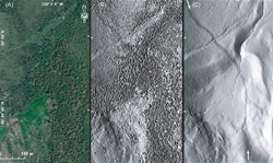
Discovering underlying features.
Archaeology
LiDAR has many applications in the field of archaeology including aiding in the planning of field campaigns, mapping features beneath forest canopy, and providing an overview of broad, continuous features that may be indistinguishable on the ground. LiDAR can also provide archaeologists with the ability to create high-resolution digital elevation models (DEMs) of archaeological sites that can reveal micro-topography that are otherwise hidden by vegetation. LiDAR-derived products can be easily integrated into a Geographic Information System (GIS) for analysis and interpretation.
Beyond efficiency, its ability to penetrate forest canopy has led to the discovery of features that were not distinguishable through traditional geo-spatial methods and are difficult to reach through field surveys.
Cellular Network Planning
With the ability to collect large areas of high-resolution data in a relatively short space of time, LiDAR provides the perfect data for cellular network planning. The detailed information can be incorporated into statistical or GIS software and used to provide accurate analysis for determining line of sight and view shed for proposed cellular antenna. This analysis has the benefit of creating the optimal site for the masts ensuring coverage is optimal whilst reducing costs in the process.
Ground-based LiDAR Mapping
Recreating real-world arenas with laser scanning.
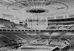
Visualisation and Gaming
LiDAR allows any physical object to be re-created in a computer environment. Whether it's a building, a car or a whole country, LiDAR has the ability to reproduce a number of scenes. Once in the digital realm they can be rendered using a pseudo-colour representation of the real-world point or they can be transferred to 3D software and be recreated with actual photographic textures mapped onto the surfaces. This enables the user to create highly detailed, accurate models in a very short space of time when compared to other modelling methods. In the gaming industry this can be used for a number of purposes. It will allow the quick and precise creation of whole cities. It can also be used to recreate every undulation in a race track, giving the gamer the most accurate reproduction of their favourite circuit.
EA Games have been using laser scanning technology to recreate scenes such as the interior of Madison Square Gardens for thier NBA Live game as well as for games such as Tiger Woods PGA Tour and NCAA Football. Using LiDAR systems allows them to capture the scenes in great detail and extremely quickly.
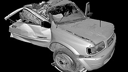
Recreating accident scenes using LiDAR scanning.
Scene of Accident/Crime
Because of its real-world application, LiDAR systems make recording the scene of accidents and crime quick and easy, as well as precise. By using a ground based LiDAR system it is possible to record the scene a car accident within a few minutes, enabling the emergency services to clear the scene and then to reproduce it later on in the digital realm. This reduces traffic jams as well as preserving the evidence before anything is compromised. All of the data is recorded with a geographical position that allows the data to be used in various software packages for an extra level of accuracy.
Architecture
LiDAR is a useful tool when designing and constructing new buildings. A ground based LiDAR survey can be undertaken to give a precise digital representation of the surrounding area and buildings. The ground can also be represented from a ground based scan but the sensor should be moved to different locations to ensure all details are captured.
Building Restoration
Using a ground based LiDAR survey it is possible to capture minute details in building facades. This detail is a valuable record of the current condition of a building and can be used as the basis for a digital restoration before any work takes place. The three-dimensional data can also be printed out using the latest in 3D Printing technology to provide a exact scale model of the property.
The use of ground based LiDAR is not limited to outdoor use though. Using the sensor inside a building it is possible to determine the location of specific items within the interior of a room. This can useful when trying to determine the location of fire doors, the size of a bar or dance floor in a club or to determine the acoustic qualities of a room when combined with noise models. In turn, this data can be used for licensing act regulations and provided as proof of compliance.
Navigation
LiDAR is becoming more and more popular as a guidance system for autonomous vehicles. The speed and accuracy of a scanner means that data can be passed to a system to process the return in more or less real-time. This allows the device controlling the vehicle to detect obstacles and to update its route in a very small amount of time.
Sewer and Manhole Maintenance
LiDAR data can also be obtained by sensors mounted on remotely controlled vehicles. This enables surveys to be taken of places that may be considered too dangerous for humans to enter. A robotic vehicle can be sent down sewers and take detailed surveys of the interior of the system. It is also possible for the airborne pollutants to be measured at the same time.
Meteorology
The first LiDARs were used for studies of atmospheric composition, structure, clouds, and aerosols. Initially based on ruby lasers, LiDARs for meteorological applications were constructed shortly after the invention of the laser and represent one of the first applications of laser technology.
Elastic backscatter LiDAR is the simplest type of LiDAR and is typically used for studies of aerosols and clouds. The backscattered wavelength is identical to the transmitted wavelength, and the magnitude of the received signal at a given range depends on the backscatter coefficient of scatterers at that range and the extinction coefficients of the scatterers along the path to that range. The extinction coefficient is typically the quantity of interest.
Differential Absorption LiDAR (DIAL) is used for range-resolved measurements of a particular gas in the atmosphere, such as ozone, carbon dioxide, or water vapour. The LiDAR transmits two wavelengths: an "on-line" wavelength that is absorbed by the gas of interest and an off-line wavelength that is not absorbed. The differential absorption between the two wavelengths is a measure of the concentration of the gas as a function of range. DIAL LiDARs are essentially dual-wavelength elastic backscatter LiDARs.
Raman LiDAR is also used for measuring the concentration of atmospheric gases, but can also be used to retrieve aerosol parameters as well. Raman LiDAR exploits inelastic scattering to single out the gas of interest from all other atmospheric constituents. A small portion of the energy of the transmitted light is deposited in the gas during the scattering process, which shifts the scattered light to a longer wavelength by an amount that is unique to the species of interest. The higher the concentration of the gas, the stronger the magnitude of the backscattered signal.
Doppler LiDAR is used to measure wind speed along the beam by measuring the frequency shift of the backscattered light. Scanning LiDARs, such as NASA's HARLIE LiDAR, have been used to measure atmospheric wind velocity in a large three-dimensional cone. ESA's wind mission ADM-Aeolus will be equipped with a Doppler LiDAR system in order to provide global measurements of vertical wind profiles. A Doppler LiDAR system was used in the 2008 Summer Olympics to measure wind fields during the yacht competition. Doppler LiDAR systems are also now beginning to be successfully applied in the renewable energy sector to acquire wind speed, turbulence, wind veer and wind shear data. Both pulsed and continuous wave systems are being used. Pulsed systems using signal timing to obtain vertical distance resolution, whereas continuous wave systems rely on detector focusing.
Geology
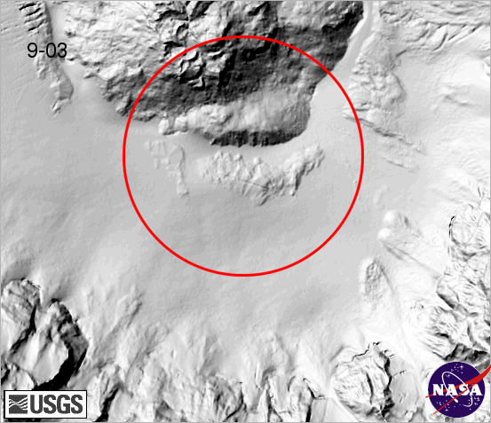
Mount St. Helens in 2004
In geology and seismology a combination of aircraft-based LiDAR and GPS have evolved into an important tool for detecting faults and measuring uplift. The output of the two technologies can produce extremely accurate elevation models for terrain that can even measure ground elevation through trees.
This combination was used most famously to find the location of the Seattle Fault in Washington, USA. It is also being used to measure uplift at Mt. St. Helens by using data from before and after the 2004 uplift. Airborne LiDAR systems monitor glaciers and have the ability to detect subtle amounts of growth or decline.
A satellite based system is NASA's ICESat which includes a LiDAR system for this purpose. NASA's Airborne Topographic Mapper is also used extensively to monitor glaciers and perform coastal change analysis.
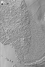
Physics and Astronomy
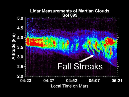
Measurement of snow from Martian clouds.
A world-wide network of observatories uses LiDAR to measure the distance to reflectors placed on the moon, allowing the moon's position to be measured with mm precision and tests of general relativity to be done. MOLA, the Mars Orbiting Laser Altimeter, used a LiDAR instrument in a Mars-orbiting satellite (the NASA Mars Global Surveyor) to produce a spectacularly precise global topographic survey of the red planet.
In September 2008, NASA's Phoenix Lander used LiDAR to detect snow falling in the atmosphere of Mars. The snow, however, sublimates before reaching the ground.
In atmospheric physics, LiDAR is used as a remote detection instrument to measure densities of certain constituents of the middle and upper atmosphere, such as potassium, sodium, or molecular nitrogen and oxygen. These measurements can be used to calculate temperatures. LiDAR can also be used to measure wind speed and to provide information about vertical distribution of the aerosol particles.
At the JET nuclear fusion research facility, in the UK near Abingdon, Oxfordshire, LiDAR Thomson Scattering is used to determine Electron Density and Temperature profiles of the plasma.
Biology and conservation
LiDAR has also found many applications in forestry. Canopy heights, biomass measurements, and leaf area can all be studied using airborne LiDAR systems. Similarly, LiDAR is also used by many industries, including Energy and Railroad, and the Department of Transportation as a faster way of surveying. Topographic maps can also be generated readily from LiDAR, for recreational use such as in the production of orienteering maps.
In oceanography, LiDAR is used for estimation of phytoplankton fluorescence and general biomass in the surface layers of the ocean. Another application is airborne LiDAR bathymetry of sea areas too shallow for hydrographic vessels.
LiDAR allows research scientists to not only measure the height of previously unmapped trees but to determine the biodiversity of the forest. This technology will be useful in directing future efforts to preserve and protect ancient trees.
Military and law enforcement
One situation where LiDAR has notable non-scientific application is in traffic speed law enforcement, for vehicle speed measurement, as a technology alternative to radar guns. The technology for this application is small enough to be mounted in a hand held camera "gun" and permits a particular vehicle's speed to be determined from a stream of traffic.
Unlike RADAR which relies on Doppler shifts to directly measure speed, police lidar relies on the principle of time-of-flight to calculate speed. The equivalent radar based systems are often not able to isolate particular vehicles from the traffic stream and are generally too large to be hand held.
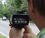
Police laser speed detector.
LiDAR has the distinct advantage of being able to pick out one vehicle in a cluttered traffic situation as long as the operator is aware of the limitations imposed by the range and beam divergence. Contrary to popular belief LiDAR does not suffer from "sweep" error when the operator uses the equipment correctly and when the LiDAR unit is equipped with algorithms that are able to detect when this has occurred. A combination of signal strength monitoring, receive gate timing, target position prediction and pre-filtering of the received signal wavelength prevents this from occurring. Should the beam illuminate sections of the vehicle with different reflectivity or the aspect of the vehicle changes during measurement that causes the received signal strength to be changed then the LiDAR unit will reject the measurement thereby producing speed readings of high integrity.
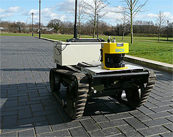
A LiDAR guided robot.
For LiDAR units to be used in law enforcement applications a rigorous approval procedure is usually completed before deployment. Jelly-bean shaped vehicles are usually equipped with a vertical registration plate that, when illuminated causes a high integrity reflection to be returned to the LiDAR, many reflections and an averaging technique in the speed measurement process increase the integrity of the speed reading. In locations that do not require that a front or rear registration plate is fitted headlamps and rear-reflectors provide an almost ideal retro-reflective surface overcoming the reflections from uneven or non-compliant reflective surfaces thereby eliminating "sweep" error. It is these mechanisms which cause concern that LiDAR is somehow unreliable. Most traffic LiDAR systems send out a stream of approximately 100 pulses over the span of three-tenths of a second. A "black box," proprietary statistical algorithm picks and chooses which progressively shorter reflections to retain from the pulses over the short fraction of a second.
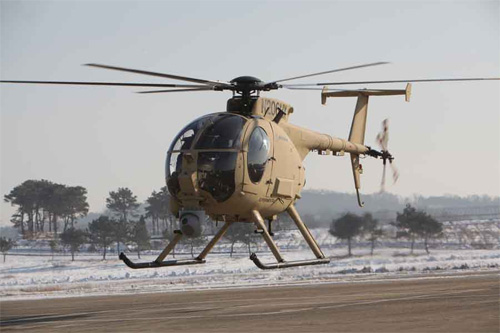
Boeing AH-6 Unmanned Little Bird.
Military applications are very similar to commercial use. A considerable amount of research is underway in their use for imaging. Their higher resolution makes them particularly good for collecting enough detail to identify targets, such as tanks. Here the name LaDAR is more common. LaDAR is proving to be increasingly useful in the autonomy of robots, allowing the computers that control them to produce digital maps of the surrounding area and obsticles. LiDAR/LaDARs ability to differentiate between distances, combined with complex algorithms enable to robots to identify terrain from objects in their path. This kind of autonomy is useful in both UAVs (Unmanned Aerial Vehicles) and specific task autonomous robotics such as bomb disposal units.
In June 2010 a Boeing AH-6 light attack and reconnaissance helicopter performed a fully autonomous flight, using LiDAR to avoid obstacles.
Vehicles
LiDAR has been used to create Adaptive Cruise Control (ACC) systems for automobiles. Systems such as those by Siemens and Hella use a LiDAR device mounted in the front of the vehicle to monitor the distance between the vehicle and any vehicle in front of it. Often, the lasers are placed onto the bumper. In the event that the vehicle in front slows down or is too close, the ACC applies the brakes to slow or stop the vehicle. When the road ahead is clear, the ACC allows the vehicle to speed up to speed preset by the driver.
Stanley
LiDAR is also being incorporated into a development called Pre-Scan where a laser scans the road surface several hundred times a second. This information is then fed to the cars on-board computer and processed in a fraction of a second which adjusts the individucal suspension at each wheel. The aim of this tecehnology is to achieve the smoothest and safest ride possible by preempting the wheel and tyres reactions to imperfections in the road surface or warn about obstacles and pot holes.
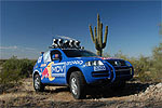
Five LiDAR units produced by the German company Sick AG were used for short range detection on Stanley, the autonomous car that won the 2005 DARPA Grand Challenge. This competition is held on a regular basis and invites teams from around the world to build an autonomous vehicle capable of driving in traffic and performing complex manoeuvres such as merging with traffic, passing another car, parking and negotiating intersections.
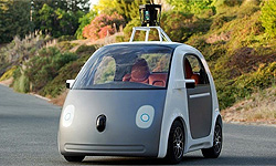
Google's driverless cars.
The Google Self-Driving Car is a project by Google that involves developing technology for autonomous cars, mainly electric cars. The software powering Google's cars is called Google Chauffeur.
Google's robotic cars have about $150,000 in equipment including a $70,000 LIDAR system. The range finder mounted on the top is a Velodyne 64-beam laser. This laser allows the vehicle to generate a detailed 3D map of its environment. The car then takes these generated maps and combines them with high-resolution maps of the world, producing different types of data models that allow it to drive itself.
As of June 2014, the system works with a very high definition inch-precision map of the area the vehicle is expected to use, including how high the traffic lights are; in addition to on-board systems, some computation is performed on remote computer farms.
Imaging
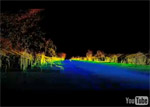
Radiohead's LiDAR video.
3-D imaging is done with both scanning and non-scanning systems. "3-D gated viewing laser radar" is a non-scanning laser radar system that applies the so-called gated viewing technique. The gated viewing technique applies a pulsed laser and a fast-gated camera. There are ongoing military research programmes in Sweden, Denmark, the USA and the UK with 3-D gated viewing imaging at several kilometres range with a range resolution and accuracy better than ten centimetres.
Coherent Imaging LiDAR is possible using Synthetic Array Heterodyne Detection which is a form of optical heterodyne detection that enables a staring single element receiver to act as though it were an imaging array.
The making of the House of Cards video.
Imaging LiDAR can also be performed using arrays of high-speed detectors and modulation sensitive detectors arrays typically built on single chips using CMOS and hybrid CMOS/CCD fabrication techniques. In these devices each pixel performs some local processing such as demodulation or gating at high speed down converting the signals to video rate so that the array may be read like a camera. Using this technique many thousands of pixels / channels may be acquired simultaneously. In practical systems the limitation is light budget rather than parallel acquisition.
LiDAR has been used in the recording of a music video without cameras. The video for the song "House of Cards" by Radiohead is believed to be the first use of real-time 3D laser scanning to record a music video. See the actual video by clicking on the image to the left or click the image on the right to view the behind-the-scenes making of documentary.